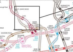
He vist a Boing-Boing el post Geographically representative map of the London Underground on es pot veure la diferència entre el mapa que es reparteix habitualment a usuaris i turistes i la situació geogràfica real. Això passa en general pertot arreu, però potser a Londres es nota més. En el mapa que es propociona en aquest post, a més s’hi poden veure estacions en desús, enllaços entre vies, andanes, etc. – amb força detall.
The Transport for London tube map, building on Harry Beck’s pioneering work in 1931, is rightly hailed as a masterpiece of simplification and clarity in data visualisation.
But it’s only when the familiar map is compared with this map, showing the actual geographic relationships of stations and the layout of TfL’s tracking, that you really begin to understand what a fantastic, gnarly, organic hairball the tube system actually is. It’s also a great source of plot devices, showing all the different places that trains can be diverted to.
El metro de Londres passa sovint molt a sota de la superfície, i cal pujar i baixar vàries escales mecàniques. Això despista una mica. Aquest mapa ajuda a situar-s’hi.
